Press Releases
20-01-2020 13:38
Definitions of Ground Elevation terms as used in everyday weather bulletins
Elevation values are rounded and refer to heights above mean sea level
Following are some useful definitions of some geographical altitude and ground elevation terms, as used in various daily weather bulletins issued by the Department of Meteorology, aiming to clarify and make them more comprehensible by the general public. The definitions are based on a relative European arrangement:
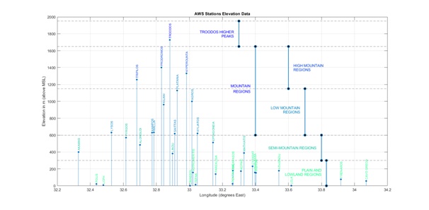
A. “Troodos’ higher peaks”: This is defined as the elevation zone from Troodos’ square up to mount Olympus peak, i.e. Troodos’ highest peak. In other words, this is the zone beginning at an altitude of 1650 metres (5500 feet) and ending at 1950 meters (6400 feet).
B. “Mountain Regions”:This is the elevation zone from 600 to 1650 metres (2000-5500 feet). This zone is distinguished into two parts:
1. “High Mountain regions”: 1150-1650 metres (3800-5500 feet),
2. “Low Mountain Regions”: 600-1150 metres (2000-3800 feet).
C. “Semi-Mountain Regions”: This is defined as the zone between 300 and 600 metres (1000-2000 feet).
D. “Plain and Lowland Regions”: This is the elevation zone starting from mean sea level up to 300 meters (1000 feet).
The following graph is a schematic representation of the above elevation zones, including various geographic names corresponding to existing automatic weather stations of the Department of Meteorology.
(EH/SCH)